
Glanteenassig Forest Park – A Hidden Paradise on the Dingle Peninsula
I’m always searching for those locations that haven’t yet been discovered by the masses. Of course, you visit the main attractions when you’re in the area, but every now and then you find a gem that remains largely unexplored. Glanteenassig is one such place. During our stay on the Dingle Peninsula, we visited this magnificent area. A day in nature with beautiful walking routes and, above all, peace and quiet.
About Glanteenassig Forest Park
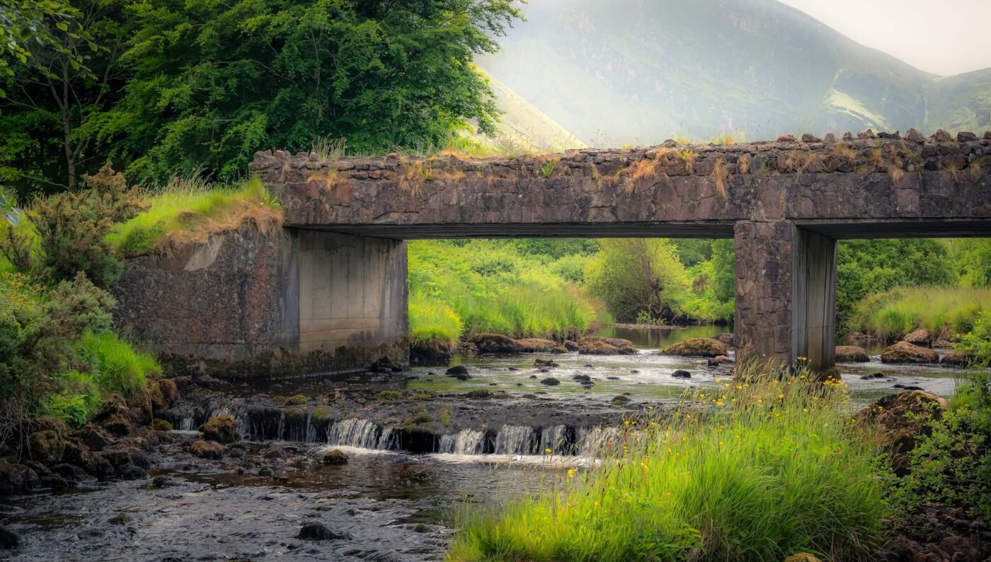
Glanteenassig (Irish: Gleann Tí an Easaigh, meaning “valley of the house by the waterfall”) is one of the best-kept secrets of the Dingle Peninsula. This expansive nature reserve of 450 hectares lies hidden in a sheltered valley at the foot of the Slieve Mish Mountains, offering a magical combination of forests, lakes, peatland, and mountain landscape.
The park is managed by Coillte (Ireland’s forestry service) and is a true paradise for nature lovers. The forests date largely from the 1950s and 60s, with extensive coniferous woodlands of Sitka spruce and lodgepole pine. But those who venture deeper into the forest will also discover pockets of silver fir, larch, and beech, alongside native species such as birch, alder, and holly.

The heart of the park is formed by two beautiful mountain lakes: Lough Slat and Lough Caum. Surrounded by dense forests and with the dramatic cliffs of Carrigaspanai (also known as “Spaniard’s Rock”) in the background, this area feels like a fairytale world – especially in the early morning when mist still hangs above the water.
| Location | Dingle Peninsula, County Kerry |
| Area | 450 hectares (1,100 acres) |
| Lakes | Lough Slat and Lough Caum |
| Mountain range | Slieve Mish Mountains |
| Management | Coillte (Irish Forestry Service) |
| Entry | Free |
| GPS | 52.2049° N, -10.0489° W |
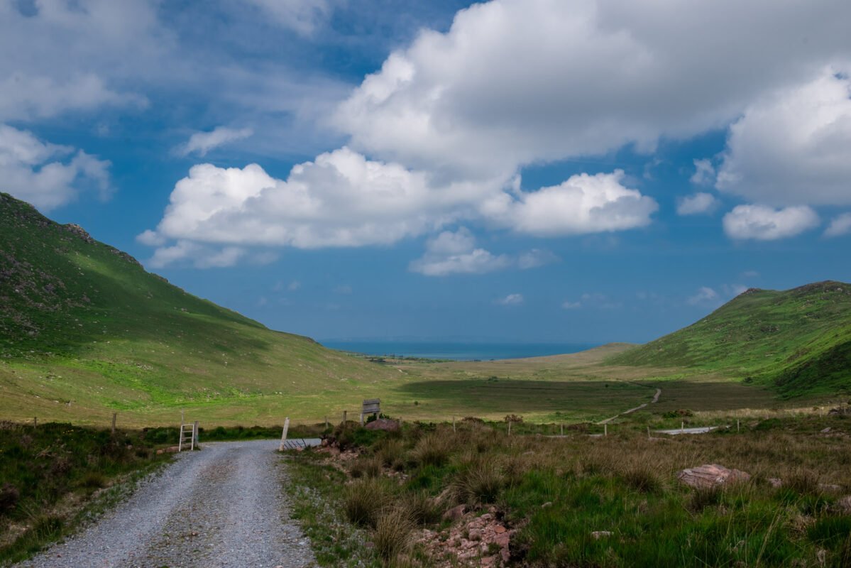
Location and How to Get There
Glanteenassig is located on the Dingle Peninsula, approximately 8 km south of the village of Castlegregory and about 24 km west of Tralee. The park is accessible via the R560 – at the village of Aughacasla, turn off towards the mountains.
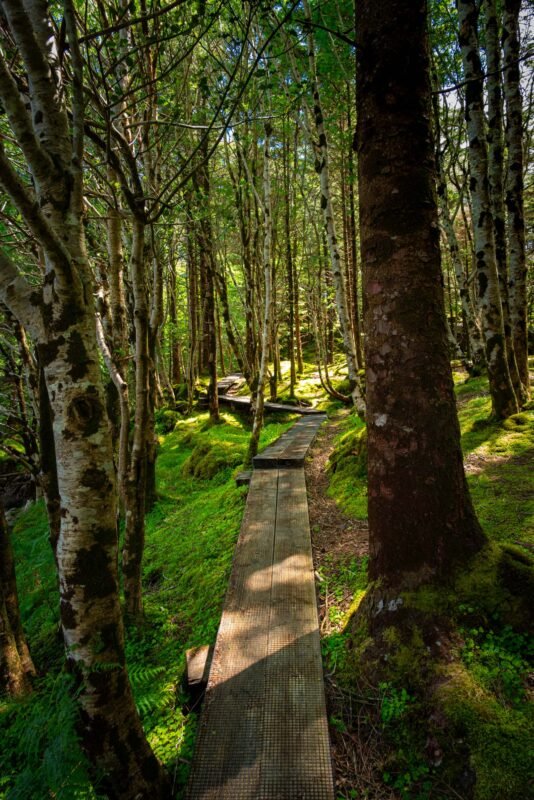
The road to the park is narrow and winding, which is part of its charm but also requires some caution. There are several car parks: one at the lower entrance, and higher car parks at Lough Slat and Lough Caum. The upper car park (at Lough Caum) provides direct access to the spectacular boardwalk around the lake.
Important: The park has restricted opening hours and the gates are locked at night! Summer: 08:00-22:00, winter: 08:00-18:00. If you’re still inside after closing time, you won’t be able to leave and there’s a call-out fee to have the gates unlocked. Always check the sign at the entrance for current closing times!
| Parking | Free, multiple car parks (limited capacity) |
| From Tralee | ~24 km (~40 min) |
| From Dingle | ~25 km (~40 min) |
| From Castlegregory | ~8 km (~15 min) |
| Opening hours summer | 08:00 – 22:00 |
| Opening hours winter | 08:00 – 18:00 |
Photography at Glanteenassig
For photographers, Glanteenassig is a dream. The combination of mirror-like lakes, moss-covered trees, mysterious forests, and dramatic mountain walls offers endless possibilities. The area has something magical about it – you can easily imagine elves and other mythical creatures darting between the trees.
Photography tip: Visit the park early in the morning for the best light. In the early hours, a layer of mist often hangs above the lakes, creating a fairytale atmosphere. Bring a tripod for long exposures at the waterfalls and pack a polarising filter for the water.
Weather tip: The weather in Kerry can change quickly. Light rain or mist actually makes this a fantastic location – the forests truly come alive with glistening droplets on the mossy branches. Don’t forget rain protection for yourself and your camera!

Walking Routes at Glanteenassig
Glanteenassig Forest Park is a dream destination for those who love being active outdoors. It’s an expansive area with numerous walking possibilities. It’s simply a matter of choosing your own route. There are three official walking trails, each with its own character:
Official Walking Routes
| Route | Distance | Duration | Level |
| Lough Slat Viewpoint | 0.3 km | ~10 min | Easy (accessible) |
| River Trail | 1.1 km | ~30 min | Easy |
| Lough Caum Loop | 2 km | ~60 min | Moderate |
The Lough Caum Loop is the most spectacular route: a wooden boardwalk that winds around the lake, with breathtaking views of the surrounding mountains. Note: the boardwalk is narrow and one-way only – if you end up behind slower walkers, overtaking isn’t possible.
Lough Caum and Lough Slat Route
Below are some routes that take you from the car park to the lakes Lough Slat and Lough Caum:
| Distance | 7.5 km |
| Duration | approximately 2 hours |
| Difficulty | Moderate |
| Terrain | Sand, grass, gravel, easy-to-walk paths |
Here’s a slightly longer variant that combines both lakes and the forests:
From Castlegregory
For enthusiasts, here’s a longer route from Castlegregory – ideal if you want a full day’s hiking.
| Distance | approximately 17 km |
| Duration | 4-5 hours |
| Difficulty | Moderate |
| Terrain | Moderate hike. Good fitness required. Easy-to-walk paths. |
Best Time to Visit
Glanteenassig is a beautiful destination year-round, but each season has its own character:
| Spring (March-May) | Fresh greens, wildflowers, waterfalls at their best |
| Summer (June-Aug) | Longest days, busier, lush greenery |
| Autumn (Sept-Nov) | Autumn colours, mushrooms, mist over the lakes |
| Winter (Dec-Feb) | Bare trees reveal structure, very quiet |
Tip: The park can get quite busy on sunny days – especially the car parks fill up quickly. Come early in the morning for the best experience: fewer people, better light, and more chance of spotting wildlife. The perfect alternative to a beach day when the weather turns!
The Surrounding Area
The Dingle Peninsula offers much more to discover near Glanteenassig:
- Inch Beach – one of Ireland’s most beautiful beaches (~35 min drive)
- Camp Beach – quiet beach with views of Tralee Bay (~20 min)
- Conor Pass – spectacular mountain pass with breathtaking views
- Slea Head Drive – iconic coastal route around the Dingle Peninsula
- Mount Brandon (952 m) – the highest mountain on the Dingle Peninsula
- Dingle Town – colourful harbour town with pubs and restaurants
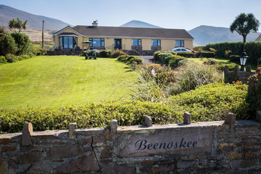
Accommodation in the Area
During our road trip through Ireland, we mostly stayed in B&Bs. It’s a wonderful way to connect with the Irish people, as well as other travellers. This time, we had booked a stay at Beenoskee Bed and Breakfast. A wonderfully friendly older couple runs this B&B. The owner goes out of her way to make you feel at home and serves up a delicious breakfast every morning.
If you want to eat nearby, I can really recommend Tomásíns Bar. A typical Irish pub atmosphere where you can enjoy delicious food at friendly prices. It doesn’t take long before you’re chatting with the locals who pop in for a drink or a bite to eat.
Other good bases include Castlegregory (close to the park), Tralee (larger town with all amenities) or Dingle (atmospheric harbour town).
Practical Information
Getting There
| From Dublin | ~320 km (~4 hours) |
| From Cork | ~140 km (~2 hours) |
| From Killarney | ~55 km (~1 hour) |
| Nearest airport | Kerry Airport (25 km) or Shannon (120 km) |
| Access road | Via R560, turn off at Aughacasla |
Facilities
- Entry: Free
- Parking: Free, limited capacity (arrive early!)
- Toilets: Not available – come prepared
- Picnic tables: Yes, at Lough Slat and scattered throughout the park
- Food & drink: None in the park – bring your own
- Camping: Not permitted
- Dogs: Welcome, on lead
- Fishing: Permitted with licence (trout)
What to Bring
- Sturdy footwear: The boardwalk can be slippery when wet
- Rain jacket: The weather in Kerry is unpredictable
- Picnic & water: No facilities in the park
- Camera: This is a photogenic location
- Insect repellent: Midges can be present in summer months
Frequently Asked Questions
How do you get to Glanteenassig Forest Park?
Glanteenassig is located on the Dingle Peninsula, approximately 8 km south of Castlegregory. Follow the R560 and turn off at Aughacasla towards the mountains. The road is narrow and winding, but manageable. There are several car parks in the park.
How much does it cost to visit Glanteenassig?
Entry to Glanteenassig Forest Park is completely free. Parking is also free, but capacity is limited – arrive early on busy days.
What are the opening hours of Glanteenassig?
The park is open in summer from 08:00 to 22:00 and in winter from 08:00 to 18:00. The gates are locked at night – pay close attention to closing time to avoid getting stuck inside!
Is Glanteenassig suitable for children?
Yes, Glanteenassig is well suited for families with children who can walk independently. The Lough Caum boardwalk is adventurous but not suitable for pushchairs. Children often find it exciting to walk through the “fairytale forest”.
Can you camp at Glanteenassig?
No, camping is not permitted at Glanteenassig Forest Park. The gates are locked at night. There are campsites nearby, such as at Camp and the Maharees.
What is the best time to visit Glanteenassig?
The park is beautiful year-round. For photography, the early morning hours are ideal, when mist hangs over the lakes. On busy days, it’s best to arrive early. The park is also a great alternative to a beach day when the weather turns.
Final Thoughts
Glanteenassig is one of those rare places where you can truly escape the crowds. No tourist buses, no souvenir shops – just you, nature, and the silence of the mountains. It’s precisely these kinds of hidden gems that make Ireland so special. If you’re on the Dingle Peninsula, definitely take the time to discover this magical corner of Kerry.
In my photo book Ireland – Land of Stories and Rugged Coasts, you can get a wonderful impression of the west coast of this magnificent country through many beautiful photographs. Most locations also include QR codes giving you direct access to additional location information.
Useful Links
- Coillte – Official park info and map: coillte.ie
- Discover Kerry – Tourist information Kerry: discoverkerry.com
- Dingle Peninsula – Visitor info: dingle-peninsula.ie
- AllTrails – Walking routes Glanteenassig: alltrails.com
- Met Éireann – Irish weather forecast: met.ie
Location on Map
Related Articles
- Cliffs of Moher – Ireland’s most famous cliffs
- Fanore Beach – wild beach on the west coast
- Inisheer (Aran Islands) – island adventure on Ireland’s west coast
- Abbey Island at Derrynane – walking to the ruins
Gallery
Pictures speak louder than words:


