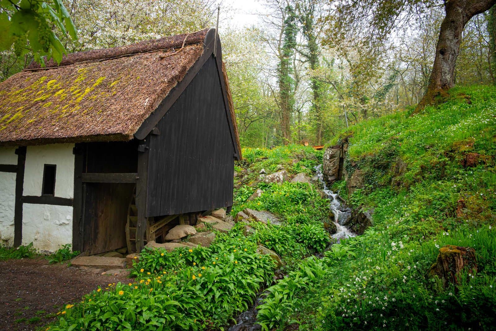

About this place
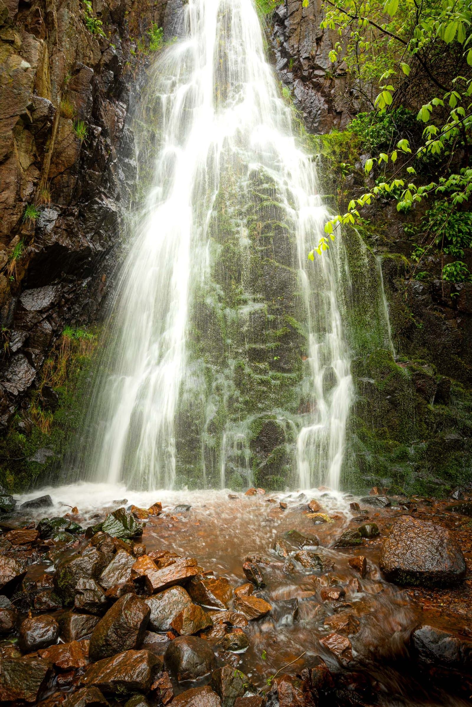
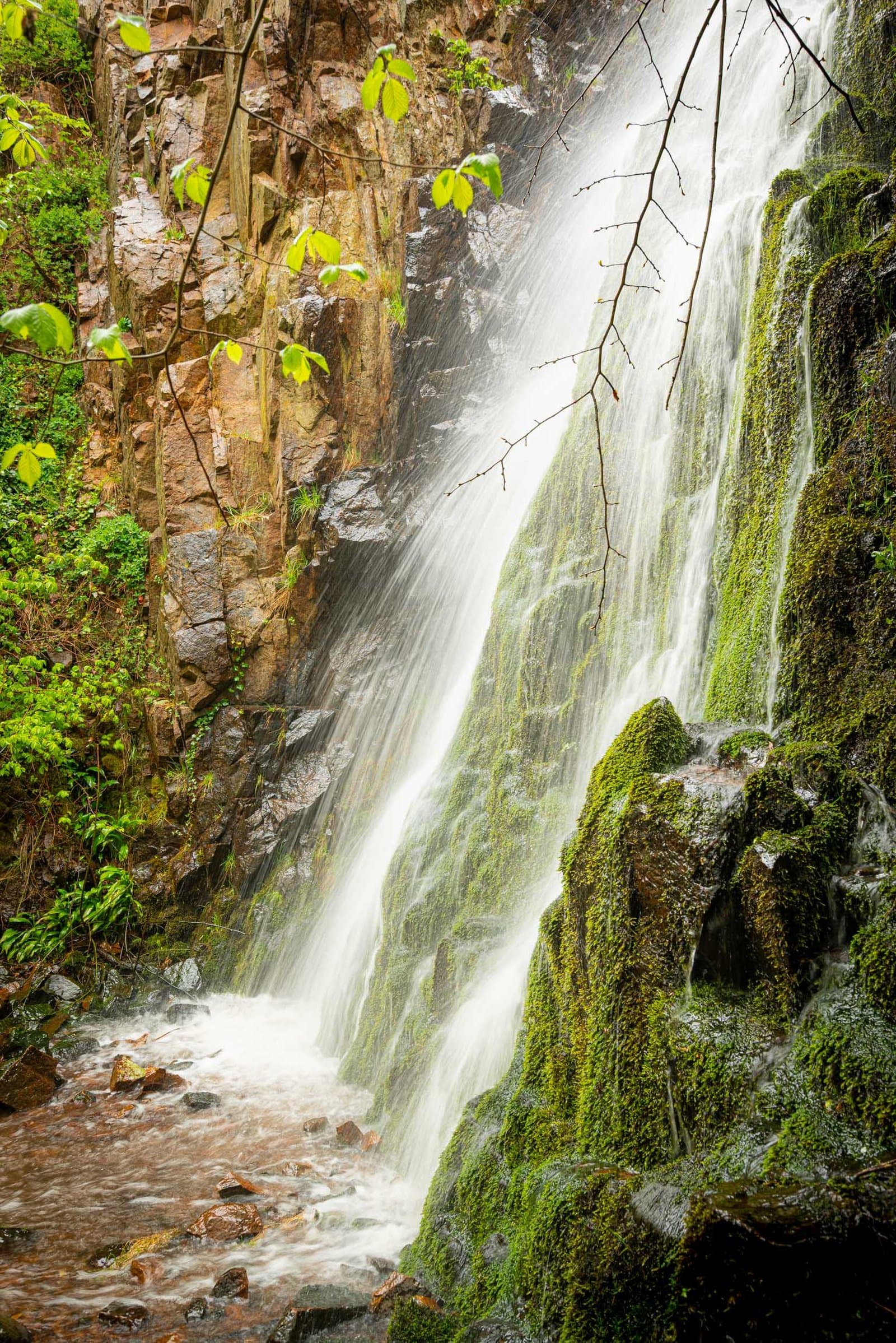
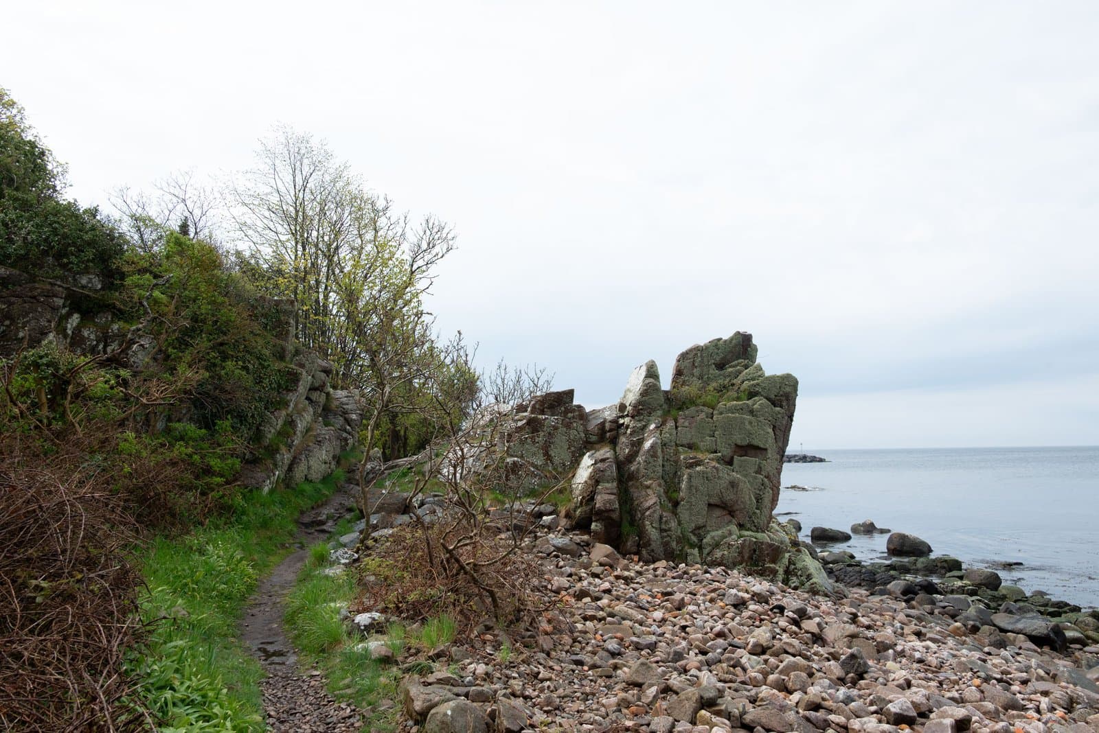
Tucked away in the forested cliffs between Allinge and Tejn lies Pissebækken, one of Bornholm’s most enchanting natural spots — a small waterfall hidden in a deep, shaded ravine. Despite its humorous name (which literally translates as “the Pee Stream”), this is one of the island’s most beautiful and atmospheric places, a pocket of cool air, moss, and running water amid the granite landscape. The stream flows gently through a narrow gorge before tumbling down a series of steps into the sea below, forming one of Denmark’s highest natural waterfalls.
The setting feels almost secret. A narrow trail winds through the woods, where sunlight filters softly through the canopy of birch and pine. Ferns and moss cover the rocks, and the sound of falling water echoes through the valley long before you see it. After rain, the waterfall is at its best — a silver ribbon spilling over dark stone, surrounded by lush green. In summer, it becomes a tranquil oasis from the heat and brightness of the coast, while in autumn the entire ravine glows gold and amber.
For photographers and hikers alike, Pissebækken offers a scene of quiet intimacy — small in scale but rich in atmosphere. The contrast between the soft foliage, the rugged granite, and the motion of water makes it a perfect place to slow down, observe, and capture detail. A few steps beyond the fall, the stream meets the Baltic, where cliffs open up and the sound of waves mixes with the whisper of the forest behind you.
Best time to visit
- After rain, when the waterfall is strongest.
- Morning or late afternoon for soft light filtering through trees.
- Spring for vibrant greens, autumn for warm tones and mist.
Practical tips
- Parking at coastal road between Allinge and Tejn (signposted “Pissebækken”).
- Short forest walk (500 m) to the waterfall — uneven terrain, can be slippery. But much better, take the hiking route from Vang all the way up to the Hammershus viewpoint. It is one of the most beautifull hiking routes on the Island.
- Wear waterproof shoes; bring tripod for long exposures.
- No facilities; quiet natural area best visited with care and respect.
Golden Hour & Blue Hour
00:32
Morning Nautical twilight Start
01:53
Morning Civil twilight Start
01:13
Morning Blue hour Start
02:43
Morning Sunrise Start
02:48
Morning Golden hour Start
18:16
Evening Golden hour End
19:14
Evening Sunset Start
20:44
Evening Blue hour End
20:04
Evening Civil twilight End
21:25
Evening Nautical twilight End
Times calculated from coordinates using suncalc.
Current weather

13°C
clear sky
- Feels like
- 12°C
- Humidity
- 88%
- Wind speed
- 6.2 m/s
- Wind direction
- W (258°)
- Sunrise
- 02:42
- Sunset
- 19:12
Hourly forecast
- Feels like:
- 12°C
- Humidity:
- 86%
- Wind speed:
- 3 (Gentle breeze)
- Wind direction:
- W
- Cloud cover:
- 7%
- Dew point:
- 10.1°C
Photography tips
- The waterfall framed by moss-covered rocks and ferns.
- Long-exposure shots capturing smooth water and deep green tones.
- Forest textures and filtered light through trees.
- The small stream winding toward the Baltic shore.
- Autumn colors and reflections after rainfall.
Hiking tips
- Pissebækken loop: short 1–2 km walk through forest and along coast.
- Tejn–Allinge coastal trail: 6–7 km route passing the waterfall, with sea views and forest sections.
- Terrain: rocky and damp in places; moderate difficulty.
- Ideal for combining forest, waterfall, and coastline photography.
Routes
Hikes & rides from here
View on Hammershus – Hammershus Ruins roundtrip from Vang
- Distance
- 16.6 km
- Ascent
- 221 m
- Descent
- 221 m
- Duration
- 4h 45m
This circular route from Vang takes you through the wildest stretch of Bornholm — the granite plateau of Hammerknuden, where the wind is a constant presence and the landscape carries something ancient and unyielding. The route is demanding without being dramatic: nearly seventeen kilometres of endlessly shifting terrain — rocky paths, wooded valleys, open heath — where the elevation doesn't so much accumulate as keep asking for more. This is a walk for people who enjoy a full day on their feet and aren't particularly in a hurry to arrive anywhere.
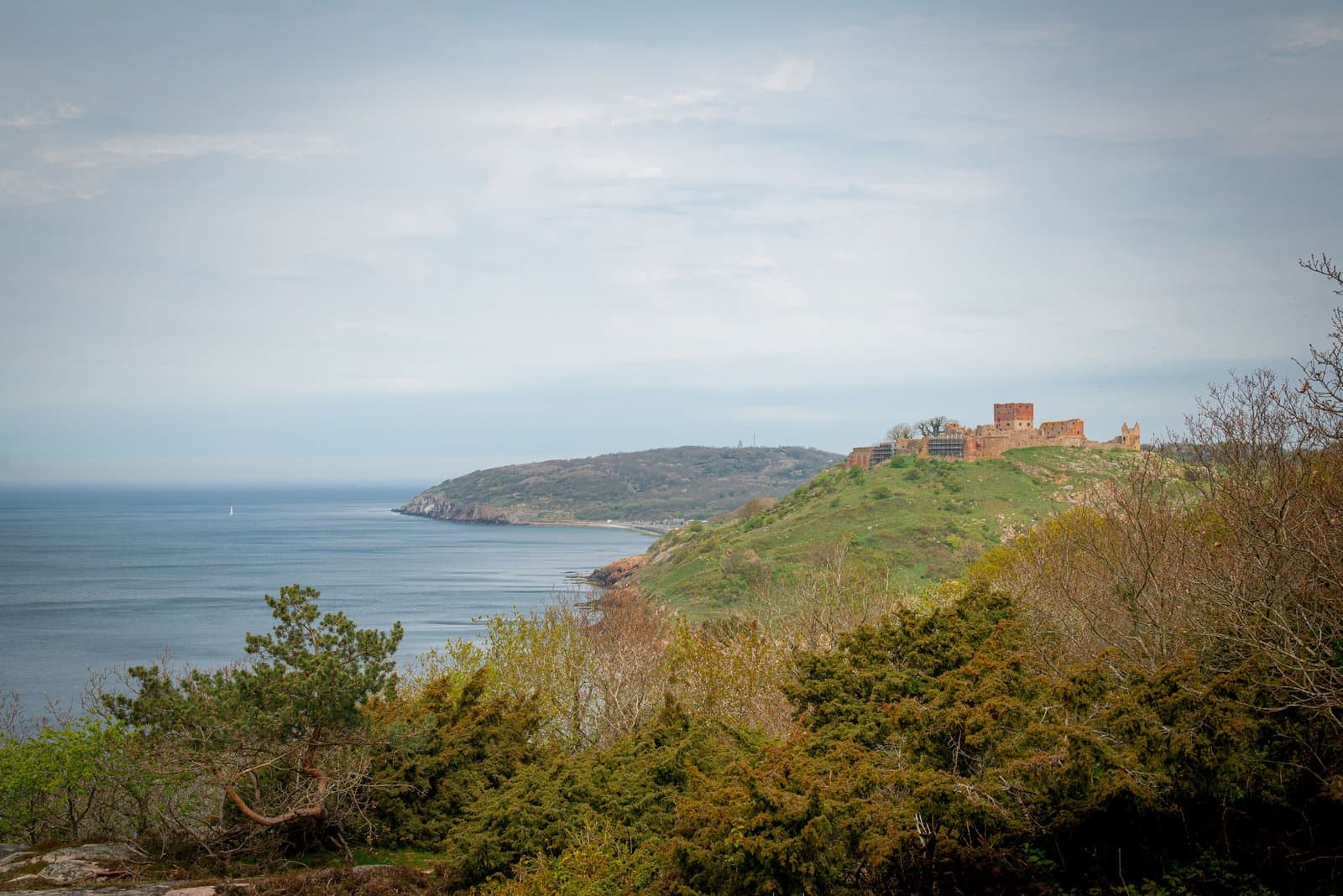
Early on, the path dips into shadow at [pissebaekken], a small waterfall tucked into a deep gorge between the cliffs — one of those places you'd nearly miss if you didn't know to look. From there the landscape opens toward [hammerso], the quiet lake wedged between granite and sky, and just beyond it the surprisingly emerald water of [opalso-lake], which has an almost otherworldly quality in the hard northern light. The route eventually pulls toward the tip of the island: at [hammerodde-fyr] a small lighthouse stands out on the headland, and at [hammer-odde] itself you feel the land simply run out — granite blocks tumbling straight into the Baltic, with nothing beyond them.
The return leg passes [hammershus-slotsruin], the vast castle ruin perched high on a granite spur above the sea. Photographically, this is a place that rewards patience: the walls read differently as the light turns, and the combination of weathered stone, open sky and coastline in the distance gives you a great deal to work with. Those cycling the route should expect rough sections that require walking — though that feels fitting here. Hammerknuden is not a place that adjusts itself to you.
Finnedalen – Vang Harbor loop from Kirkeby
- Distance
- 4.4 km
- Ascent
- 53 m
- Descent
- 63 m
- Duration
- 1h 13m
This loop from Kirkeby is an unhurried, manageable walk that takes you through two very different faces of Bornholm. The terrain is forgiving — little elevation change, the paths are reasonably easy underfoot — but the surroundings have enough character to hold your attention. You begin inland, through the quiet, lightly wooded corners of Finnedalen, where light filters down through the trees and the bustle of the island quickly falls away. After about an hour, the mood shifts completely.
Reaching the coast, the scene opens onto [vang]: a small harbour village built around the raw, weathered granite rocks that make Bornholm's west coast so distinctive. The stones here look as though they've been kneaded by wind and water for centuries, and the lingering atmosphere of a working fishing village makes it more than just a photo stop — it's a place that makes you pause for a moment. On the return, tucked into the cliffs along the forest path, [pissebaekken] waits: a small waterfall hidden in a narrow, shadow-filled ravine. You hear it before you see it, which makes finding it all the more satisfying.
The route suits anyone who wants to move at a gentle pace without too much exertion — and it's equally rewarding for photographers who want time to linger over the details of granite, water and harbour grey. The combination of inland and coast in under five kilometres makes this one of the more versatile loops in this part of Bornholm.
Passes by
Gallery