
Contents(35)
- 01Tre Cime di Lavaredo – The Icon of the Dolomites
- 02About Tre Cime di Lavaredo
- 03Location and How to Get There
- 04Alternatives to Driving
- 05History of the Three Peaks
- 06First Ascents
- 07World War I
- 08The Surrounding Area
- 09Rifugi (Mountain Huts)
- 10Lakes
- 11Other Attractions
- 12Photography at the Tre Cime
- 13Walking Routes at the Tre Cime
- 14Route 1: The Classic Loop
- 15Route 2: Rifugio Fonda Savio from Lago d’Antorno
- 16Best Time to Visit
- 17Accommodation in the Area
- 18Mountain Huts (Rifugi)
- 19Hotels and Chalets
- 20Practical Information
- 21Access and Costs (2025)
- 22Facilities
- 23What to Bring
- 24Frequently Asked Questions
- 25How do you get to Tre Cime di Lavaredo?
- 26How much does the toll road to Tre Cime cost?
- 27How long does the loop walk around Tre Cime take?
- 28When is the best time to visit Tre Cime?
- 29Is the hike suitable for children?
- 30Can I stay overnight at the Tre Cime?
- 31Final Thoughts
- 32Useful Links
- 33Location on Map
- 34Related Articles
- 35Gallery
Tre Cime di Lavaredo – The Icon of the Dolomites
When you say Dolomites, you say Tre Cime di Lavaredo – or as German speakers call it: Drei Zinnen. It’s arguably the most iconic location in the Dolomites. Three mighty rock towers rising like battlements from the Alpine landscape. Recognisable, impressive, and characteristic of this beautiful UNESCO World Heritage Site. Naturally, we couldn’t skip this spot during our visits to the Dolomites.

The Drei Zinnen at sunset
About Tre Cime di Lavaredo
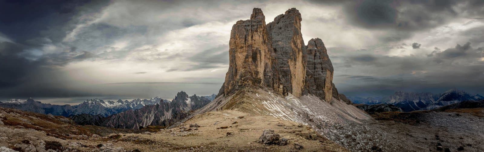
The Tre Cime di Lavaredo (Italian for “Three Peaks of Lavaredo”) or Drei Zinnen (German for “Three Merlons”) are three distinctive rock peaks in the Sexten Dolomites in northeastern Italy. They’re among the best-known mountain groups in the entire Alps and have been part of the UNESCO World Heritage Site since 2009.
The three peaks, from east to west, are:
Cima Piccola / Kleine Zinne – 2,857 metres (“little peak”)
Cima Grande / Große Zinne – 2,999 metres (“big peak”)
Cima Ovest / Westliche Zinne – 2,973 metres (“western peak”)
The peaks are composed of dolomite, a sedimentary rock formed approximately 200-250 million years ago on the floor of an ancient sea. What makes the Tre Cime so special is their freestanding character – the three towers stand completely isolated, creating a spectacular silhouette from all directions.

The three iconic peaks
The most famous phenomenon is the enrosadira – the “pink glow” that the peaks acquire at sunset when the dolomite rock turns orange, pink, and purple. This is the moment photographers from around the world come to capture.
Location | Sexten Dolomites, South Tyrol/Belluno border |
Highest peak | Cima Grande – 2,999 m |
UNESCO status | World Heritage Site since 2009 |
Rock type | Dolomite (200-250 million years old) |
Nature park | Parco Naturale Tre Cime / Drei Zinnen Naturpark |
GPS Rifugio Auronzo | 46.6167° N, 12.3000° E |
Location and How to Get There
The Tre Cime are located on the border between the provinces of South Tyrol (Bolzano) and Belluno (Veneto). The famous north face belongs to the municipality of Toblach/Dobbiaco, while the south side belongs to Auronzo di Cadore. This border is also the linguistic boundary between the German-speaking and Italian-speaking parts of the region.
The starting point for most hikes is Rifugio Auronzo (2,333 m), accessible via a spectacular toll road from Lago di Misurina.
If you’re driving to the car park, don’t forget to take several breaks along the way. Everywhere you look, you’ll see stunning views – the panoramic road is an experience in itself.

Views on the way to the car park – stop frequently!
Important – New from 2025: Car access to the Rifugio Auronzo car park is only possible with an online reservation in advance. Reservations can be made up to 30 days ahead via pass.auronzo.info. The toll is €40 per car (2025 prices) and your parking ticket is valid for 12 hours.
From Cortina d’Ampezzo | ~23 km (~35 min) |
From Toblach/Dobbiaco | ~28 km (~40 min) |
From Auronzo di Cadore | ~32 km (~45 min) |
Toll road (2025) | €40 car / €26 motorcycle / €60 campervan |
Reservation | Mandatory via pass.auronzo.info |
Toll road open | Late May – early November |
Alternatives to Driving
Shuttle bus: From Dobbiaco, Misurina and Cortina, shuttle buses run to Rifugio Auronzo (Bus 30/31 and 444)
On foot from Misurina: ~3 hours, 450 metres elevation gain – free parking at Lago d’Antorno
From the north: Via Val Fiscalina or Val Campo di Dentro (longer hikes)
History of the Three Peaks
The Tre Cime have a rich history that extends far beyond today’s tourism.
First Ascents
The first official ascent of Cima Grande took place in 1869 by Viennese alpinist Paul Grohmann, together with local guides Franz Innerkofler and Peter Salcher. The north face – one of the most challenging climbing routes in the world – wasn’t conquered until 1933, by Emilio Comici and the Dimai brothers.
World War I
During World War I (1915-1918), the Tre Cime formed the front line between Italy and Austria-Hungary. The mountains became the stage for the so-called “White War” – a battle fought not only against the enemy but primarily against the mountains themselves. Snowstorms, avalanches, and freezing temperatures claimed more victims than bullets.
Both armies carved an extensive network of tunnels, trenches, and bunkers into the rocks – remnants of which you can still see today around Rifugio Locatelli and Forcella Lavaredo. The famous mountain guide Sepp Innerkofler was killed here on 4 July 1915 on Monte Paterno.
After the war, South Tyrol was ceded to Italy, and the “Drei Zinnen” also became officially known as “Tre Cime di Lavaredo”.
The Surrounding Area
The Tre Cime are situated in an area full of other attractions:
Rifugi (Mountain Huts)
Rifugio Auronzo (2,333 m) – starting point for most hikes, car park, restaurant
Rifugio Lavaredo (2,344 m) – 30 min from Auronzo, private hut from 1954
Rifugio Locatelli / Dreizinnenhütte (2,405 m) – iconic hut with views of the north face
Rifugio Fonda Savio (2,367 m) – above Lago di Misurina
Lakes
Lago di Misurina – beautiful mountain lake with views of the Tre Cime
Lago d’Antorno – small lake by the toll road, starting point for hikes
Laghi dei Piani – two small lakes along the circular walk
Other Attractions
Cadini di Misurina – spectacular mountain group, famous viewpoint
Monte Paterno (2,744 m) – mountain with WWI tunnels
Cortina d’Ampezzo – host city of the 2026 Winter Olympics

Everywhere you look there are interesting compositions
Photography at the Tre Cime
For photographers, this is one of the most iconic locations in the Alps. The combination of dramatic rocks, Alpine lakes, and the famous “enrosadira” at sunset makes this an unforgettable destination.
Photography tip – Sunset: The best sunset photos are taken from Forcella Lavaredo (the saddle between Rifugio Lavaredo and Rifugio Locatelli) or from Lago d’Antorno. For the perfect “enrosadira”, you need to be there between late May and early August – when the sun shines directly on the north face without shadows from other mountains.
Photography tip – Sunrise: Stay overnight at Rifugio Locatelli to experience sunrise above the Tre Cime. Book well in advance – this hut is extremely popular!
Equipment: Bring a wide-angle lens for the panoramas, a polarising filter for the blue sky, and optionally ND filters for long exposures at the lakes. Don’t forget your tripod for sunrise and sunset!
Walking Routes at the Tre Cime
There are many hiking options in this beautiful area. The classic loop with all the iconic views is naturally on everyone’s list.
Route 1: The Classic Loop
This is THE walk you need to do: a complete circuit around the Tre Cime with spectacular views of both the south and north faces. The route passes all the important rifugi and the famous WWI trenches.
Distance | ~10 km |
Duration | 4-5 hours (incl. breaks) |
Elevation gain | ~400 m |
Difficulty | Moderate |
Start/Finish | Rifugio Auronzo |
Direction | Counter-clockwise recommended |
Tre cime di Lavaredo met de Rifugio Antonio Locatelli - rondwandeling
Hike
10.0 km
Distance
↑ 294 m
Ascent
↓ 302 m
Descent
3 h 25 min
Duration
Route 2: Rifugio Fonda Savio from Lago d’Antorno
As I mentioned, there are countless options in the area. This route starts at Lago d’Antorno and offers beautiful views of the Cadini di Misurina.
Distance | ~8 km |
Duration | 3-4 hours |
Difficulty | Challenging |
Start/Finish | Lago d’Antorno |
Rifugio Savio Fonda - rondleiding vanaf Lago d'Antorno
Hike
7.4 km
Distance
↑ 485 m
Ascent
↓ 479 m
Descent
3 h 24 min
Duration
Best Time to Visit
The Tre Cime are best visited during the summer months when the toll road is open and the hiking trails are snow-free.
June | Toll road opens, still quiet, possible snow on higher trails |
July-August | Best weather, all facilities open, VERY busy |
September | Quieter, autumn colours, chance of early snow |
October | Last chance for toll road, changeable weather |
Winter | Toll road closed, only for experienced winter hikers |
Tip to avoid crowds: Visit the Tre Cime early in the morning (before 8:00) or late in the afternoon (after 16:00). July and August are extremely busy – up to 7,000-8,000 visitors per day! Consider an overnight stay at Rifugio Locatelli to experience both sunset and sunrise in relative peace.
Accommodation in the Area
For a visit to the Tre Cime, you have several options:
Mountain Huts (Rifugi)
The most authentic experience is an overnight stay in one of the mountain huts. Rifugio Locatelli is the most popular due to its iconic view of the north face. Book well in advance – these huts are fully booked months ahead!
Note: Mountain huts only accept cash! There’s no wifi or ATM. Bring enough cash for your overnight stay and meals.
Hotels and Chalets
Chalet Lago Antorno – directly at Lago d’Antorno, at the foot of the toll road
Hotels at Lago di Misurina – beautifully located, good base
Cortina d’Ampezzo – upscale ski resort, ~30 min drive
Dobbiaco/Toblach – quiet town in South Tyrol, ~40 min drive
Practical Information
Access and Costs (2025)
Toll road car | €40 (reservation mandatory) |
Toll road motorcycle | €26 |
Toll road campervan | €60 |
Shuttle bus | ~€4 per person |
On foot (free) | Parking at Lago d’Antorno (€2/hour, max €14) |
Reservation | pass.auronzo.info (30 days in advance) |
Facilities
Parking: Large car park at Rifugio Auronzo (~700 spaces)
Toilets: At Rifugio Auronzo (public)
Restaurant/café: At all rifugi along the route
Payment: CASH only at mountain huts!
What to Bring
Sturdy hiking boots: The terrain is rocky and can be slippery
Warm clothing: At 2,500+ metres it can be cold, even in summer
Sunscreen and sunglasses: UV radiation is intense at altitude
Water and snacks: The rifugi aren’t cheap
Cash: Essential for mountain huts
Camera: You’ll want to capture these views!
Frequently Asked Questions
How do you get to Tre Cime di Lavaredo?
The most common route is via the toll road from Lago di Misurina to Rifugio Auronzo. Since 2025, online reservation is mandatory via pass.auronzo.info. Alternatives are the shuttle bus or hiking from Lago d’Antorno (~3 hours).
How much does the toll road to Tre Cime cost?
In 2025, the toll road costs €40 for a car, €26 for a motorcycle, and €60 for a campervan. Online reservation is mandatory. The ticket is valid for 12 hours and includes parking.
How long does the loop walk around Tre Cime take?
The classic loop is approximately 10 km and takes 4-5 hours including breaks. The route is of moderate difficulty, but don’t underestimate it – at 2,500 metres altitude, you’ll feel the effort more quickly.
When is the best time to visit Tre Cime?
The toll road is open from late May to early November. July and August are the busiest (up to 8,000 visitors per day). June and September offer a good balance between weather and crowds. Come early in the morning or late in the afternoon to avoid the rush.
Is the hike suitable for children?
Yes, the loop walk is suitable for children who are used to mountain hiking. The paths are wide and well-marked. Keep the altitude in mind – children may tire more quickly.
Can I stay overnight at the Tre Cime?
Yes, there are several mountain huts (rifugi) where you can stay overnight. Rifugio Locatelli is the most popular due to its iconic view. Book well in advance – especially in July and August, the huts are fully booked months ahead. Note: cash only!
Final Thoughts
The Drei Zinnen is a magnificent location. If you’re in the Dolomites, don’t skip this spot. Yes, it’s a busy place. But don’t let that spoil the fun. Choose your moment and work around the crowds – early in the morning or late in the afternoon, or consider an overnight stay in one of the mountain huts.
Don’t forget the surrounding area either. It’s a beautiful region with impressive nature, rich history, and countless opportunities to enjoy it all – with or without a camera.
In my photo book Dolomites – A Journey Through Breathtaking Heights, you can get a wonderful impression of this magnificent region through many beautiful photographs. Most locations also include QR codes giving you direct access to additional location information.
Useful Links
Parking Reservation Tre Cime – pass.auronzo.info
Auronzo Tourism – auronzo.info
Drei Zinnen Dolomites – drei-zinnen.info
Rifugio Locatelli – rifugiolocatelli.com
Dolomiti Bus – Bus connections: dolomitibus.it
Tre Cime Nature Park – provinz.bz.it
Location on Map
Related Articles
Lago Federa – Hidden mountain lake in the Dolomites
Lago di Braies – The pearl of the Dolomites
Val di Funes – The magic of Santa Maddalena
Seceda and Col Raiser – Spectacular mountain peaks
Seiser Alm – The high plateau of the Dolomites
Gallery
Pictures speak louder than words: